Cruising and trip planning · Bahamas
Bahamas Cruising and Trip Planning Guide
Compare Bahamas cruising areas, prepare for the crossing, and explore a worked example with clear mileage, time and fuel assumptions.
Planning your own Bahamas cruise?
Use FPW to build your route, estimate fuel and organize the details before departure.
Start with one cruising area
A first trip becomes easier to revise when it has a clear arrival area, a workable return and a few optional local days. Choose your region before building a list of distant stops. Research each actual approach, overnight arrangement and service separately.
On a narrow screen, scroll the map horizontally. Open the full bahamas regional overview. The table below provides the same locations.
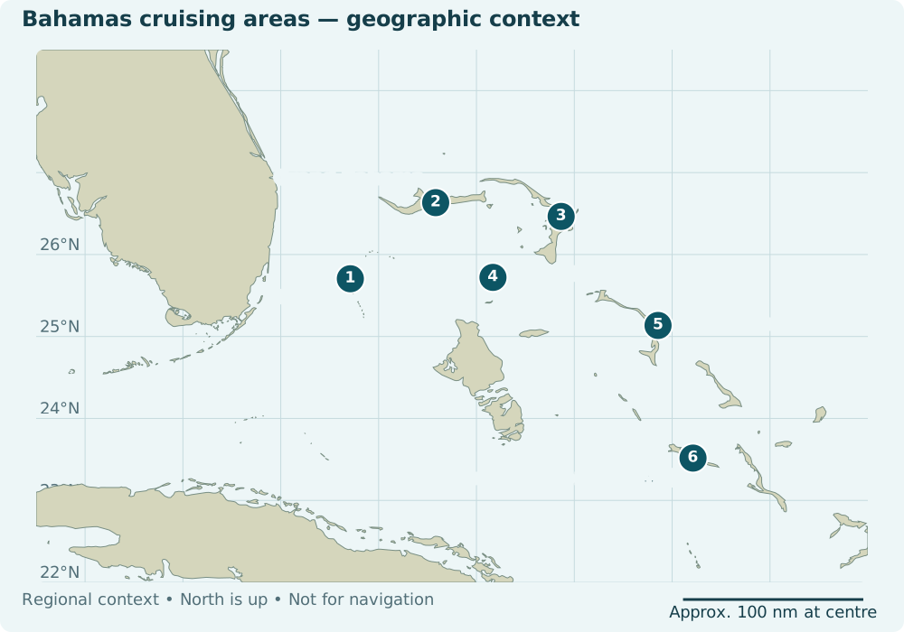
| Region | Planning focus | First confirmation task |
|---|---|---|
| 1 · Bimini | A flexible Florida crossing and local stay | Arrival reference, harbor approach, clearance and a separate berth/fuel plan |
| 2 · Grand Bahama | Compare West End and Freeport arrival areas | Exact entry destination and current clearance/service arrangements |
| 3 · Abacos | Choose a manageable stop cluster | Current local approaches, services and exposure along the chosen legs |
| 4 · Berry Islands | Research Great Harbour Cay and alternatives | Access and overnight availability; do not assume Chub Cay access |
| 5 · Eleuthera | Choose between distinct cruising areas | Approach research and local assistance where appropriate |
| 6 · Exumas | Combine flexible legs with provisioning and park research | Mooring/anchoring rules and a plan that works without a guaranteed mooring |
1 · Bimini: separate arrival, berth and fuel
The worked example starts with Port Everglades and Bimini. Treat an arrival reference, a marina destination and a confirmed berth as different things. Research the harbor approach with current charts and local information before selecting your path. Big Game Club’s FAQ says its marina has no fuel; a berth there would require a separate fueling plan.
2 · Grand Bahama: name the arrival area
West End and Freeport are different planning choices. Compare the exact arrival location, clearance arrangements and onward legs instead of entering a generic island name as a route endpoint. Begin with official Grand Bahama information and the chosen operator’s current instructions.
3 · Abacos: plan a cluster, then the connection
Choose the stops that matter to your crew, then examine each connecting passage and the services you actually need. Keep exposed connections and alternate overnight choices visible in the plan. Official Abacos information supports regional discovery; confirm operational details with individual facilities.
4 · Berry Islands: confirm access before counting a stop
A named marina is not an assured overnight option. Chub Cay’s visitor information and current membership terms require an access check. Compare Great Harbour Cay’s marina information with the services and arrival arrangements your boat needs.
5 · Eleuthera and Harbour Island: choose the actual area
Do not use a single island marker as an arrival waypoint. Use official regional information to narrow your choices, then investigate the approach, berth and local assistance for the selected destination.
6 · Exumas: keep the park plan flexible
Bahamas National Trust’s park payment policy does not guarantee a mooring through payment or reservation. Build an alternative into the itinerary. Staniel Cay Yacht Club’s service information is a starting point for provisioning research; confirm current availability directly.
Andros and other cruising areas
Keep regions outside the first example as research choices, not invented route examples. Official Andros information helps identify an area to investigate. The same endpoint, approach, fuel, communications and contingency questions apply.
Plan a crossing with room to wait
Define the Florida departure reference and Bahamas destination before comparing distances. A marina-to-marina movement includes different water from an offshore-reference comparison. Do not transfer another publisher’s number onto different endpoints.
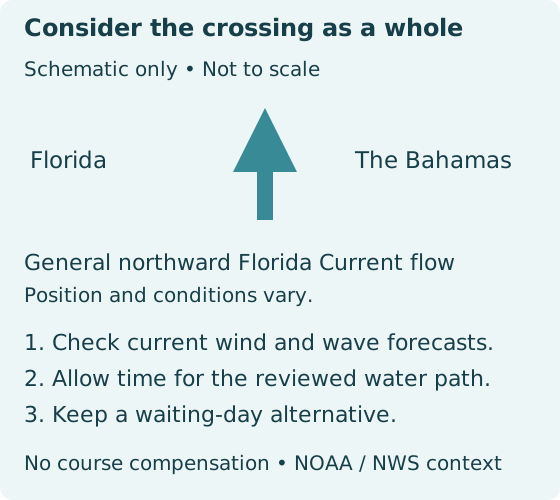
The Gulf Stream is a moving-water consideration. Wind, waves, current, passage duration and crew limits belong in the same decision. NWS explains the Gulf Stream; consult current NWS Miami marine products, National Hurricane Center marine products and Bahamas Department of Meteorology forecasts for the waters and period involved.
- Record forecast issuance and valid times, not just a screenshot.
- Work back from daylight arrival and the route your skipper has reviewed.
- Keep a departure delay, shortened stay and later return as real options.
- Recheck the return crossing independently; the outbound decision does not approve it.
Prepare entry and U.S. return before departure
Use the authorities’ current instructions for your vessel and everyone aboard. Keep the document checklist useful even when fees or eligibility change. No fee table is reproduced here.
Bahamas arrival
- Assemble vessel registration, identity/travel documents, crew details and the information required for your actual vessel and visit.
- Check an appropriate port of entry in official Bahamas boating regulations. Use Customs’ current offices and ports directory to confirm Bimini arrival arrangements before departure.
- Use Bahamas Customs’ pleasure-vessel clearance instructions and its recent-updates notice for the current digital application/payment process and in-person Customs approval.
- Check current charges, permit duration, re-entry conditions and any fishing permissions directly with Customs. Keep the approved documents available.
Returning to the United States
CBP’s pleasure-boat arrival guidance says operators returning from a foreign place must report arrival immediately. Before leaving the Bahamas, confirm the procedure for your vessel, everyone aboard and your intended U.S. arrival location.
Check CBP’s ROAM guidance for current eligibility and procedure and obtain the relevant port’s reporting alternative. The detailed ROAM and Florida reporting pages returned access errors during the November 9 check. Use CBP’s general information contact before travel to obtain the intended port’s instructions if those pages remain unavailable. A general inquiry is not an arrival report. Do not assume app eligibility, remote approval or completion of formalities.
Activities and restrictions
Check official fishing guidance and destination-specific restrictions before planning an activity. Park rules, customs permission and a marina reservation address different requirements.
Make fuel, provisions and communications explicit
Use your boat’s operating point
Enter speed in knots and total-vessel underway consumption in US gallons per hour. A per-engine burn rate, a speed in kilometres per hour or nominal tank capacity cannot be silently substituted. Confirm usable fuel and add realistic idle or auxiliary allowances.
The boat fuel calculator can help explore assumptions. The guide example uses a clearly stated 20% added reserve; it applies the reserve once. A calculation is not a finding that a crossing is safe or that fuel will be available.
Estimate fuel, range and reserve for your own boat.
Open the Fuel CalculatorConfirm services directly
Record the supplier, access requirements, operating hours and last confirmation for intended fuel, water and overnight stops. A facility list is a research lead. Carry a plan that does not depend on an unconfirmed delivery or berth.
Work through one trip, including the changed plan
First worked example
Fort Lauderdale to Bimini
A Florida staging day, outbound movement, two local days, return movement and two uncommitted weather days. Review the owner-supplied distance estimates, explore the sample calculator’s assumptions, and keep the separate 120 NM time/fuel worksheet distinct. See what changes when the return is delayed or longer.
Change the sample’s speed, fuel consumption, reserve percentage and usable fuel to explore its estimates. The guide is an educational example; sample edits stay on this page and reset when it is reloaded.
Before this becomes your trip
- Choose exact departure and destination references and research the entire intended path.
- Record a source or reproducible calculation method for each leg’s planning mileage.
- Enter speed in knots and total underway consumption in US gal/h; confirm usable fuel and reserve mode.
- Review approach, draft, weather, daylight, clearance, overnight and service constraints.
- Replace or explicitly confirm each leg’s mileage. Your review is not independent navigation verification.
- Recheck affected legs after any endpoint, mileage, source or geometry change.
- Keep missing values distinct from complete estimates; do not treat a partial subtotal as a complete-trip requirement.
- Review the completed trip and keep shore-contact expectations current.
READY TO PLAN YOUR OWN CRUISE?
Turn the guide into your own Bahamas trip.
Build your route in FPW, estimate travel time and fuel, organize your trip details, and prepare a float plan for your shore contact.
Sources and what was checked
“Retrieved” means the source was accessible and supported the described information. It does not confirm safe passage, an available berth, fuel stock or an independently verified route. Regulatory and service facts need a fresh check before use.
- Bahamas Ministry of Tourism — Entry and clearanceCurrent documents, ports and boating requirements; verify before departure. Accessed 2026-11-07. Status: retrieved.
- Bahamas Customs — Pleasure-vessel clearanceClick2Clear submission/payment does not replace in-person approval. Confirm current outbound requirements directly. Accessed 2026-11-09. Status: retrieved with conflict.
- Bahamas Customs — 2026 recent changesCurrent permit periods and in-person inbound approval described. No precise fee table republished. Accessed 2026-11-09. Status: retrieved.
- Bahamas Customs — Current Customs offices and ports contactsBimini office contacts are listed for confirming the entry location, arrival arrangements and conflicting legacy permit/outbound text. Listing does not confirm office availability for a planned arrival. Accessed 2026-11-09. Status: retrieved.
- U.S. Customs and Border Protection — United States arrival reportingCBP primary indexed Article 1029 states that arrivals from foreign places must be reported immediately. Full page returns a CSS-error shell in this environment; no claim of verified ROAM eligibility or port-specific alternative. Accessed 2026-11-09. Status: primary index text rechecked full page unavailable.
- U.S. Customs and Border Protection — ROAM procedureDetailed ROAM guidance remains inaccessible (HTTP 403) through current and legacy CBP paths. Confirm vessel/crew eligibility, inspection procedure and the intended arrival port’s alternative directly; no app-clearance promise. Accessed 2026-11-09. Status: unavailable 403.
- U.S. Customs and Border Protection — CBP information and predeparture questionsCBP publishes general inquiry channels. Use them before travel to obtain the intended port’s reporting instructions if its web guidance is inaccessible. A general inquiry is not an arrival report or clearance. Accessed 2026-11-09. Status: primary index text retrieved.
- National Weather Service Miami — Florida marine weatherOfficial marine forecasts and hazards. Accessed 2026-11-07. Status: retrieved.
- National Hurricane Center — Offshore marine productsUse the relevant zone and product times; no timeless forecast is embedded. Accessed 2026-11-07. Status: retrieved.
- Bahamas Department of Meteorology — Bahamas forecastsUse current issued forecasts rather than an archived PDF. Accessed 2026-11-07. Status: portal verified live content not extracted.
- National Weather Service Melbourne — Gulf Stream educationCurrent and wind context; no automatic heading compensation. Accessed 2026-11-07. Status: retrieved.
- Bimini Big Game Club — Historical approach-distance comparison47.6 nm is a published approach-segment comparison, not berth-to-berth validated mileage. Ambiguous Florida coordinate typography is not used for this example. Accessed 2026-11-09. Status: retrieved historical reference.
- Bimini Big Game Club — Bimini servicesThe club states that its marina has no fuel. Confirm a separate supplier. Accessed 2026-11-07. Status: retrieved.
- Chub Cay — Chub Cay accessConfirm permission and access; do not assume an overnight visit. Accessed 2026-11-07. Status: retrieved.
- Staniel Cay Yacht Club — Exumas service researchPublished services are not evidence of current stock or availability. Accessed 2026-11-07. Status: retrieved.
- Bahamas National Trust — Exuma park visitsNo guaranteed mooring from payment; use BNT over conflicting operator reservation advice. Accessed 2026-11-07. Status: retrieved.
- Natural Earth — Natural Earth10m country geographyPublic-domain context shapes for USA, The Bahamas and Cuba, clipped to regional bounds; minor-island features retained separately. Includes major Bahamas islands absent at110m. No navigational geometry. Accessed 2026-11-09. Status: downloaded.
- Natural Earth — Minor islandsPublic-domain minor-island geometry, not hydrographic data. Accessed 2026-11-07. Status: downloaded.
- GeoNames — Geographic namesCC BY geographic locators only, never arrival waypoints. Accessed 2026-11-07. Status: retrieved.
Geographic assets are original FPW renderings of Natural Earth public-domain data, with GeoNames attribution. No proprietary chart image or paid tile service is used.